Scope
- The scope of implementing the nineteenth-century Franciscan Cadastre was to determine the tax rates for various types of land, in relation to the net productivity of the soil, regardless of the owner's social status. This tax was meant to remain stable over a longer period, hence the name stable cadastre.
- In the Austrian provinces, during the period 1817–1861, measurements were carried out in a total of 30,556 cadastral communities, covering an area of 300,082 km2, which comprised 49,138,140 parcels. A total of 164,357 cadastral maps were developed, the vast majority at a scale of 1:28801. The completed maps provide a comprehensive overview of property boundaries and their land-use patterns. The areas determined based on them allowed for the estimation of yields (the basis for calculating the net income generated, and the property tax, respectively). Since they were intended for an economic mapping of the land, no details regarding topography (e.g., elevations, slope inclinations) are provided.
- The operations were carried out based on instructions; a first final version was published in 1824, but updates were also issued.
Preliminary Operations
- The first stage in conducting the provincial economic census included the development of a stable triangulation network and the establishment of a layout system for the cadastral sheets.
The network was intended to provide the framework for determinations carried out on the field using a plane table (graphical triangulation) and, above all, the accuracy of the geographical positioning of the observed details. According to the practices of the time, the premise for the measurements was determining the length of a baseline (one side of the initial triangle). This operation had to be executed with maximum precision, which is why it was preferable for the chosen terrain to be as uniform as possible.
For measuring this distance, nineteenth-century engineer-officers utilized variations of the so-called Delambre instrument (Basismess-Apparat), which consisted mainly of four standard iron rods on wooden supports (each approximately 4 m long, 13 cm wide, and 4.5 cm thick), equipped with indicators for the thermal expansion or contraction of the metal.
The works were coordinated by the newly established Triangulation Bureau (1806) within the General Staff, and from 1839 onward, by the Military Geographical Institute. High-ranking officers also coordinated the technical activity of the Cadastral Survey Department (Vermessungsdepartement) within the Court Commission for Land Tax Regulation (Grundsteuerregulierungs-Hofkommission)—the central body for implementing the stable cadastre.

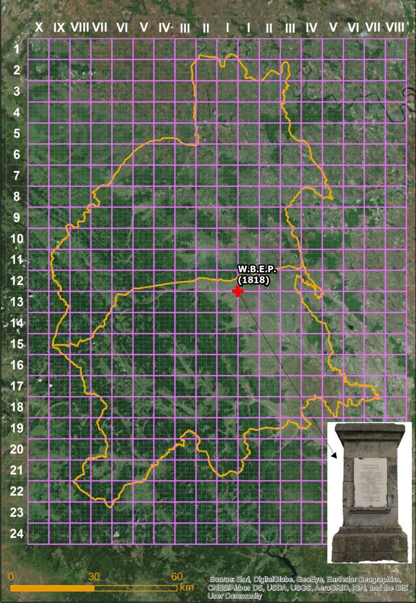
The geodetic baseline in Bukovina, measured by A. Hawliczek in 1818, had its western terminus near the locality of Gălănești and its eastern terminus south of Andrasfalva (Măneuți). The officer's report reveals that a device with Delambre metal standards constructed in 1810 was used for the measurements. From this line, all other triangulation points (generally located on prominent terrain elevations) were determined indirectly, by measuring the angles (e.g., using the baseline north of Rădăuți, the first triangles with vertices on Ursoaia Hill and Fundătura, north of Fântâna Albă, were determined). Upon the completion of the works in 1820, the endpoints of the triangulation baseline were marked by inscribed stone monuments—the earliest known geodetic markers within the current territory of Romania. Unfortunately, only the one at the western terminus (Gălănești) has survived to this day.2.
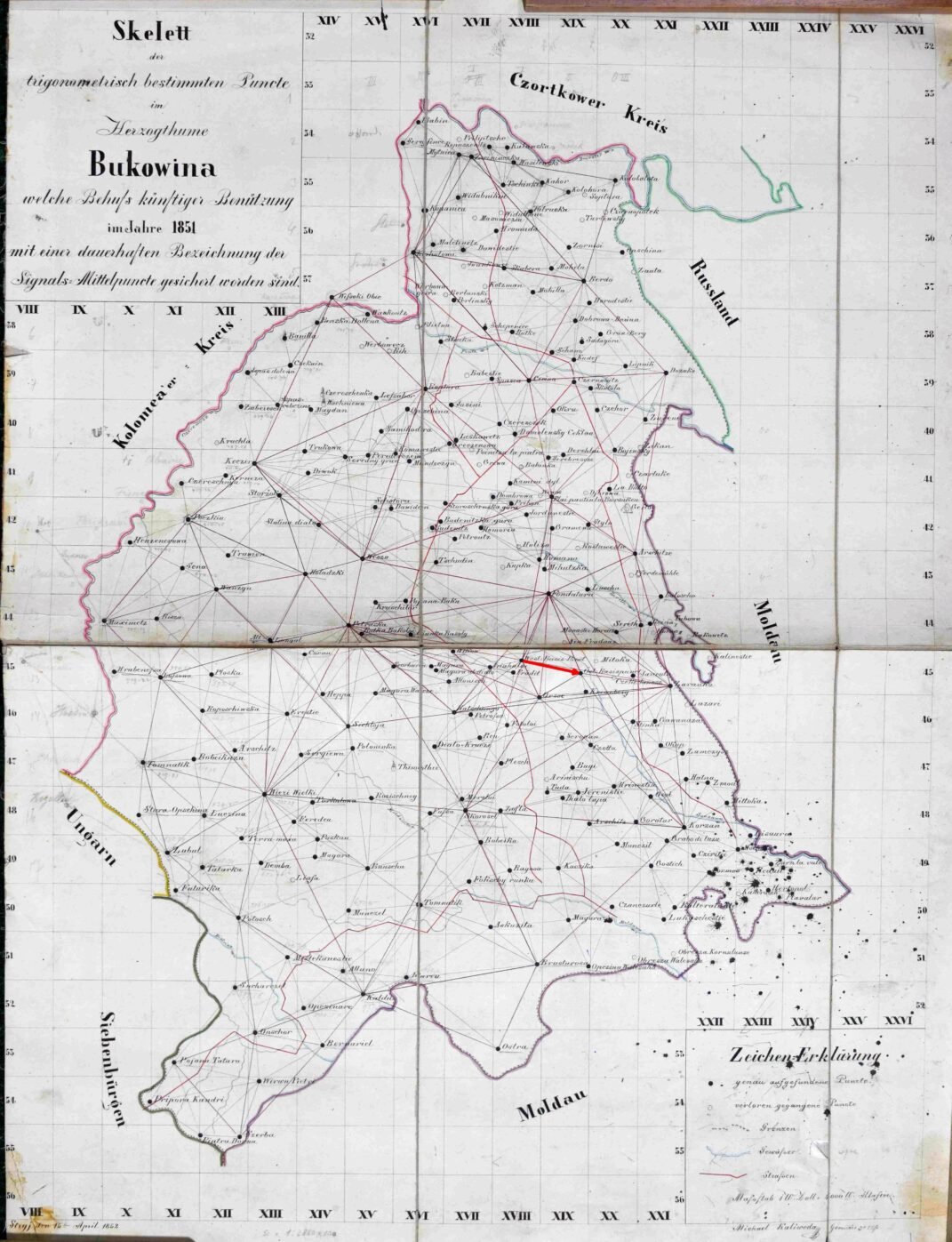
The points determined by trigonometric methods formed the support framework for the cadastral surveys. According to the regulations in force, there had to be at least three trigonometric points determined with a theodolite for every square mile (5,754.6 ha). Based on these, and with the aid of a plane table, other control points were subsequently generated, and finally, the detailing was carried out at the parcel level—operations performed by military or civilian surveyors. The points of the cadastral triangulation are marked on the maps with triangles, while those determined graphically are marked with squares.
Although, initially, the starting point of the coordinate system for the empire's triangulation was considered to be the tower of St. Stephen's Cathedral in Vienna, due to the vast expansion of the territory to be mapped and in order to limit the resulting distortions, systems with multiple origins (datum points) were used in practice.
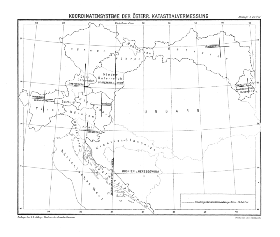
Based on these points, the map sheet grids were generated for each territory in the form of rows and columns, utilizing the Cassini projection and the Zach-Oriani ellipsoid.
The cadastral maps of Bukovina were produced during the period 1819–1823 and subsequently updated/supplemented between 1854–1856. A matrix-type system was used for their assembly, with the origin (datum point) located at the western baseline endpoint—the monument at Gălănești. From this point, the columns were numbered with Roman numerals: I–VII to the east and I–IX to the west. The rows were numbered from north to south with Arabic numerals (from 1 to 23), so that the ordinate axis (which intersected the point of origin) corresponded to the boundary between rows 12 and 13. For each grid square (one square mile), there were 20 cadastral sheets at a scale of 1:2,880, in the form of rectangles (4 columns x 5 rows, identified by letters) measuring 1,000 x 800 Vienna fathoms (1896.48 × 1517.19 m).
Production of the cadastral maps
- Detailed mapping was carried out by cadastral unit, by surveyors. These were scientifically educated individuals with practical experience. A mapping inspector was commissioned in each district to monitor the work performed by the surveyors and sign the map sheets alongside them. A director and one or more cadastral sub-directors were appointed in each province to verify the work of the inspectors.
The description and marking of the boundaries of the mapped unit was an important preliminary activity and was carried out by a commission; the boundaries of the properties within the community were marked by mutual agreement of the owners in the usual manner (boundary stones, wooden stakes, earthen mounds, ditches). If an agreement could not be reached, a separate parcel or cluster of parcels was created for the disputed area. During the subsequent detailed measurements, numerous field sketches were made, including indications regarding the owners' names, house numbers, land-use types, etc.
A working group typically consisted of an officer or a civilian graduate of a polytechnic school, an assistant, and 3–4 chainmen. The work schedule was 12–14 hours a day, from Monday to Saturday. Office work was carried out voluntarily on Sundays and public holidays to cope with performance pressures3. If you made a mistake, you had to redo the work at your own expense and during your own free time!
The working groups developed the cadastral maps and portfolios for each cadastral unit.
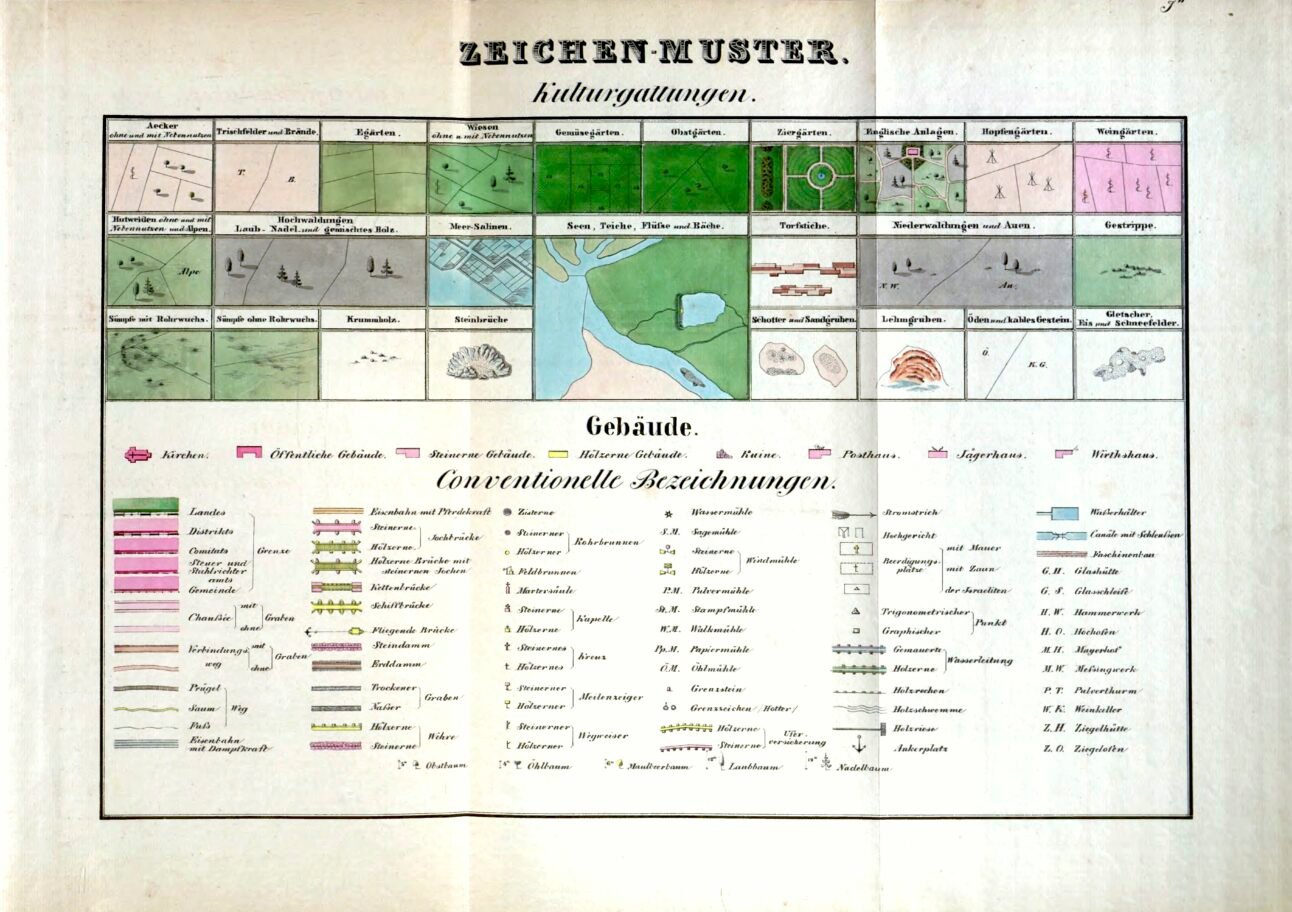
Cadastral maps reflected the field situation of land use, the boundaries of parcels and cadastral communities, the position of buildings, various types of roads, etc. In the final version, each land parcel was numbered, and arable lands, pastures, meadows, forests, gardens, orchards, marshes, unproductive lands, and waters were represented with specific colors. Wooden houses were colored yellow, while stone ones were colored red; there were different conventional signs for churches, mills, inns, forestry stations, or post offices. An almost complete list of the conventional signs used is accessible within the interactive application.
Each map had a standard format of 20 x 25 inches (526.8 x 658.5 mm).
The accuracy of the representations is influenced by a multitude of factors, including fiscal relevance. Empirically, it is considered to vary from 0.8 m (agricultural, flat terrain) up to 100 m in high mountainous areas.
The final versions were printed using specialized lithographic stones. Each stone measured 76 cm long, 63 cm wide, and 8 cm thick (approx. 30 x 25 x 3 inches), weighing around 90 kg (198 lbs). A single lithographic stone was used to produce just one sheet. According to estimates, approximately 15,739 metric tons of stone would have been required to manufacture all the lithographic stones used to reproduce the more than 164,000 cadastral maps across all Austrian provinces! The manufacturing and transportation of these stones alone incurred significant financial expenditures.
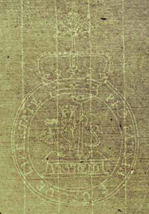
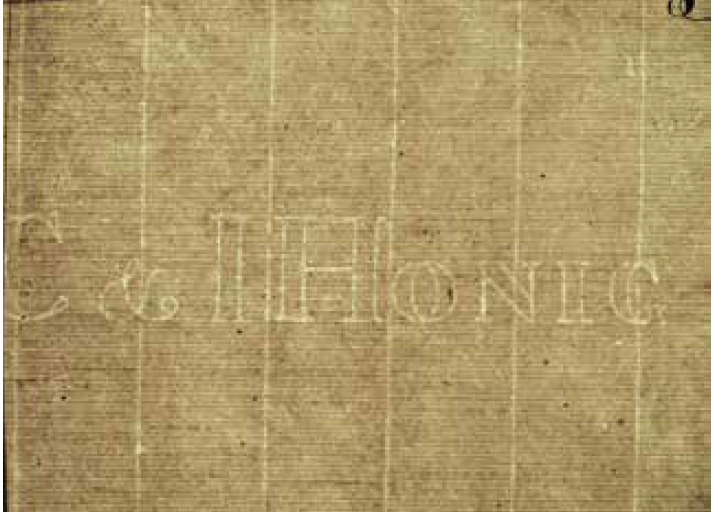
The paper used was handmade from a fiber pulp. In the light, two watermarks can be seen: PRO PATRIA EIUSQUE LIBERTATE or that of the manufacturer – C & I HONIG. The location of the mill was probably in the Netherlands – Zaandijk, near Amsterdam. Paper produced by the mills here can be found in German-speaking countries from the seventeenth century until the nineteenth century. It was utilized for all the sheets of the Franciscan Cadastre, from 1817 until the end of the project4.
Cadastral portfolios contain, for each cadastral unit, a protocol (report) of land parcels and buildings. For each parcel, it indicates the sequence number, the owner's name, the surface area in Vienna yokes and fathoms, the type of property (dominical or rustical), and the land-use type; sections detailing subsequent changes are also included. Buildings are also numbered, with various details specified (owner's name, type of construction, material used, built-up area, and subsequent changes).
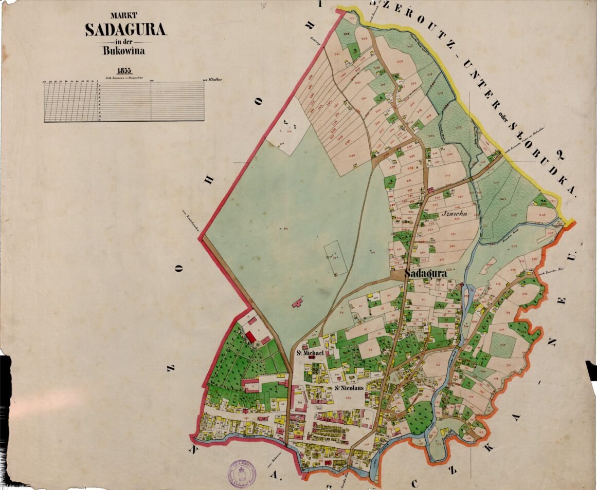
In Bukovina, the triangulation and cadastral survey works commenced in 1819 and continued until 1823. Thirty-one years later, as the old cadastral maps and portfolios no longer corresponded to reality, it was decided to resume the surveys. These began in the spring of 1854 in northern Bukovina and continued in the central and southern parts of the province until the end of 1856 – beginning of 1857. At that time, Bukovina was divided into 16 tax districts and comprised 319 cadastral units.
The cadastral maps and portfolios were developed and completed mainly by surveyors of German or Polish ethnicity who did not know the Romanian language; for this reason, the names of localities, hamlets, rivers, glades, churches, etc., were transcribed phonetically as they were heard, often butchered, using German or Polish orthography. A large number of surveyors and assistants participated in the measurements; in 1854 alone, at least 56 people were involved5.
The cadastral maps produced were subject to reambulances (updates) carried out between 1865 and 1883. These were mainly driven by inevitable changes occurring over time and the need to align their content with the land registers. The Property Tax Regulation Act of 1869 contained provisions for new operations aimed at updating cadastral files and ownership registers. On this occasion, a new edition of the 1854–1856 cadastral map sheets (V2) was lithographed. The reprinted sheets feature updated conventional signs; subsequent changes (new parcel boundaries, administrative limits, buildings, roads, changes in the hydrographic network) were marked on them in red ink, and boundaries, buildings, and property numbers that were no longer up to date were crossed out with two small dashes. Thus, areas with modifications could be quickly distinguished from those that remained unchanged. An indication of the later lithography is the inclusion of a metric graphic scale on the title sheets—the metric system having been introduced in the Austro-Hungarian Empire in 1871.


At the National Archives in Suceava and the offices of the County Cadastre and Land Registration Office, two versions of the cadastral sheets produced in 1854–1856 for Bukovina are preserved—the originals (V1) and the updated version (V2). With few exceptions, they remained unknown and inaccessible to the public until the 2008–2011 research project regarding the Franciscan Cadastre in Carinthia and Bukovina, carried out by the universities of Klagenfurt and Innsbruck and coordinated by professors Helmut Rumpler and Kurt Scharr (http://www.franziszeischerkataster.at/). On this occasion, an inventory of the preserved maps was compiled, and 5,092 sheets from the National Archives and 632 from the Cadastre Office were scanned (4,074 from the V1 edition, and the rest from V2). In fact, without this remarkable achievement, our cartographic adventure would probably not have existed!
- Constantin Ungureanu (2022), Cadastrul din Bucovina: Proprietarii de case și clădiri (1854-1856), vol. I, Ed. Karl A. Romstorfer, Suceava ↩︎
- Alexandru-Ionuţ Cristea , Cristina Cristea (2021), Moşteniri cartografice habsburgice în Bucovina, Analele Bucovinei, XXVIII 2(57) ↩︎
- Rainer Feucht, Rupert Kugler, Franz Schönweiler (2017), Von der Messtischmappe zur digitalen Katastralmappe, în 200 Jahre Kataster
Österreichisches Kulturgut 1817 – 2017, BEV – Bundesamt für Eich- und Vermessungswesen, p. 95 ↩︎ - idem , p.91 ↩︎
- Constantin Ungureanu (2011), Cadastrul austriac din Bucovina, Revista de Istorie a Moldovei. Nr. 1-2 ↩︎