The northwestern part of the Principality of Moldavia, later known as Bukovina, became a province of the Habsburg Empire in 1775. From its annexation until the dissolution of the Austro-Hungarian Monarchy in 1918, Bukovina remained a German-administered imperial province and, consequently, subject to various reforms that shaped cartography into a modern science.
Little known and underutilized, currently scattered across several archives in Vienna (Austria), Suceava, Bucharest (Romania), and Chernivtsi (Ukraine), the Habsburg maps of Bukovina offer us today a unique perspective on cartographic advancements in imperial border regions, sequentially illustrating the state's concerns and interests across various chronological periods.

The Theresian-Josephine Mapping
- The earliest systematic mapping of the empire was ordered by Maria Theresa in 1763. As a result, by 1785, all Habsburg provinces had been mapped, along with other regions of interest, such as Moldavia between the Carpathians and the Siret River, and Wallachia (with the exception of the Brăila rayah).
- The cartographic materials compiled by military personnel were classified as top-secret, accessible only to a small number of high-ranking officers, and remained, to a large extent, unknown to the public. Their creation relied on the limited instruments of the era, and they lacked reference to geographic coordinates.
A. In northwestern Moldavia, the earliest Austrian cartographic investigations preceded the annexation of Bukovina and were a product of the military-administrative necessities to integrate the provinces neighboring the principality into the Empire. Between 1769 and 1773, when Transylvania was mapped, the officers involved were requested to create detailed representations of the Carpathian border region, including parts of the internal territories of Moldavia and Wallachia.
On the occasion of his visit to Transylvania and Galicia in 1773, Joseph II criticized these preliminary results and mandated additional mapping activities in the border region by the end of the year. Furthermore, the emperor recognized the opportunity for a territorial connection between Transylvania and Eastern Galicia (annexed from Poland in 1772) through the northern part of Moldavia and requested the comprehensive mapping of the region. On this occasion, some of the officers already involved in mapping activities in Eastern Galicia were deployed to the area of interest, and the accumulated geographic information played an important role in justifying future annexation claims.
The cartographic representation of the Transylvanian border area and that of the "Galician corridor" were distinct yet partially overlapping expeditious mapping projects, designed to provide information on topography, the distribution of forests, rivers, human settlements, and transport routes for potential military operations, in accordance with the standards of the time.
- The first of them fell to the charge of the Moldavian-Wallachian border regiment and was coordinated by Major Jeney. It includes 103 map sheets covering the Carpathian border strip of the province1. Of these, 16 cover the southwestern part of the territory that would be annexed in 1775. The sheets were assembled using the system employed in Transylvania, thereby ensuring a unified geographical perspective over the neighboring territories to the east and south.

Source: maps.arcanum.com (map) & wikipedia.org (sheet assembly diagram).
- In northern Moldavia, work continued between 1773 and 1775, in parallel with the mapping activities of Eastern Galicia and the de facto occupation of Bukovina. The primary role here fell to Friedrich von Mieg, who had been tasked in 1772 with delineating the southeastern border of Galicia (in Pokuttya). In this context, the German officer emphasized the strategic importance of a military advance toward the east and documented, through sketches and reports, the fact that the border of historical Pokuttya supposedly extended into the territory of Moldavia. The arguments identified, though controversial and biased, provided Austria with a pretext for the territorial annexation of the region and were appreciated by the emperor. Consequently, at the beginning of 1774, Mieg was promoted to the rank of major and received orders to draw more precise maps of the territory roughly bounded by the Dniester and Bistrița rivers. The first detailed mapping of northwestern Moldavia and the documentation of a more advanced frontier of the Monarchy were carried out incognito, in the context of an agreement with the occupying Russian army, through a detachment of 30 military personnel transferred from Eastern Galicia. The end of the Russo-Turkish War accelerated the completion of the cartographic activities, and the Austrian maps served as valuable instruments in the subsequent negotiations with the Ottoman Empire.
The mapping of Bukovina in the early 1770s was poorly anchored in precise measurements and relied heavily on rapid visual assessments. Consequently, following the 1775 annexation, several officers were transferred here to apply modifications/corrections and finalize the assembly of the map sheets. This activity was completed in 1776.
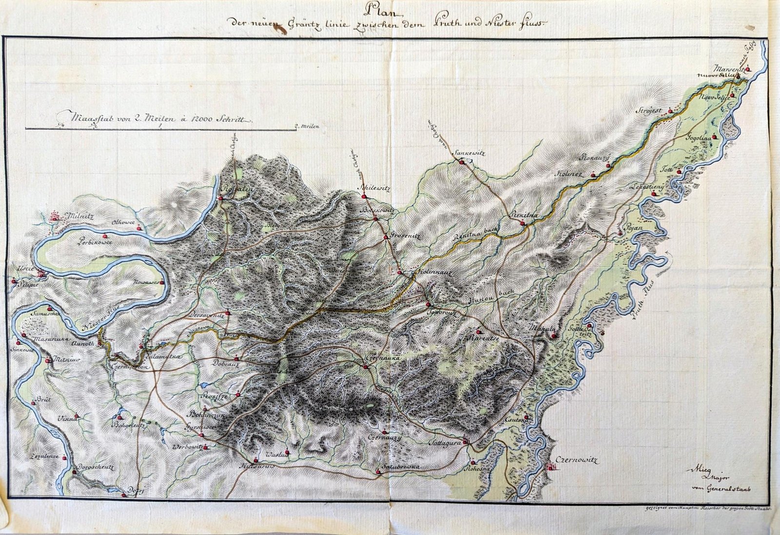
The first detailed map of Bukovina was initially created at a double military scale (approximately 1:57,600) and includes 71 main sheets, two additional sheets to the west (covering the adjacent region of Maramureș), a title page, and an index map. According to J. Paldus, two versions existed within the War Archive in Vienna—the original sheets and an updated copy (1777), which differed slightly in terms of content2. In 1778, the map was enlarged to the standard military scale (approximately 1:28,800) under the coordination of Major Mieg. This version includes 72 sheets measuring 64×42 cm, identical in extent to those produced at the 1:57,600 scale, an index map, and a title page (cartouche) depicting an amicable negotiation between the Austrians and the Turks near the Khotyn Fortress3.


As a result of the efforts of the Habsburg officers between 1773 and 1778, geographic knowledge regarding northern Moldavia was significantly enriched. The various cartographic representations created during this period (sketches or maps at different scales) emphasized, in particular, relevant strategic and military details. With an area slightly smaller than the initial claims, the district of "Austrian Moldavia" covered 10,441 km2 and comprised a relatively small population of 71,750 inhabitants, across 281 settlements.
B. The subsequent administration and economic management of the new province presented the Austrian monarchy with more challenges than its political integration, underscoring the need for new cartographic descriptions. This aspect was also indirectly highlighted by local leaders, such as the boyar Vasile Balș, who stated that:
"in Bukovina, many disputes and difficulties are encountered regarding the division of land between boyars and peasants" ... "there is hardly a single plot of land that is not entangled in boundary disputes."
At the time of the annexation, there were no official records regarding landholders in Bukovina, nor were there exact boundaries or markings of the lands owned. Consequently, it was difficult to separate state-owned properties from private ones, or the estates held by Moldavian nobles and Orthodox monasteries located outside the monarchy's borders. These issues, which ultimately affected tax collection, had been brought to the attention of Habsburg officials as early as 1777, though the analysis and delineation of land ownership began only in 1781–1782, following the establishment of a special commission of inquiry. The main tasks of this commission involved investigating and delineating, at state expense, all hereditary estates in Bukovina (based on the analysis of historical charters or witness testimonies), drafting protocols, and issuing land deeds. If an owner possessed multiple contiguous estates or villages, these were concatenated, and a single estate was defined and bounded. The inquiry was, theoretically, completed in 1784.
- In parallel with the regulatory commission's activity, the first cadastral plans were also produced in 1782. Unlike previous inquiries, the mapping of land use and its administrative delineation were carried out by 24 civil engineers, led by Johann Budinsky. By the spring of 1783, the civil land surveyors had mapped the estates of 40 settlements, most of them located in the northern half of the province. These were represented on plans at variable scales, ranging from 1:4,800 to 1:14,400, using single or multiple sheets (117 sheets in total) that highlighted a series of elements necessary for tax estimation—such as parcel boundaries/dimensions or land use types (hence the economic nature of the representations). The Aulic War Council's initiative to use civil engineers for the economic mapping of the province was soon criticized by Joseph II because it involved higher costs—estimated at around 300,000 florins (six to seven times higher than if military personnel had been used)—and the activities were halted.
- For several reasons, and particularly as a result of the emperor's decision to reform the land taxation system across the entire monarchy, the economic mapping of Bukovina was resumed in 1786. Its coordination was assigned to Captain Franz Xaver Hora von Otzellowitz, who was deployed for this purpose from the Banat region. Unlike Budinsky's mission, Otzellowitz was required to produce a cheaper, faster, and more general economic map of Bukovina („summarische geometrische Aufnahme”) at a military scale. Therefore, the activity was expected to be completed within a year. However, the outbreak of a new Russo-Ottoman war complicated the completion of the work. As an ally of Russia, Austria was forced to intervene in the conflict, and military preparations included the return of the deployed military cartographers to their respective regiments. With the support of civil engineers, the economic mapping of the province was concluded in 1789, in parallel with the mapping of the neighboring parts of Moldavia that were temporarily occupied by imperial troops.
Unlike Mieg's military map, Otzellowitz's map covers only the territory of the province. It consists of 55 sheets, an index map, and a title sheet. The standard dimensions and the scale of representation used are similar to the military sheets (64×42 cm, 1:28,800 scale)4. Considering the absence of external frame elements (e.g., title, sheet number—which are present in Mieg's work), the fine pencil sketching of the cartouche on the title page, the cutting and reassembling of certain regions within the sheets, and the presence of differences in color or conventional signs, its character as an original sketch or "brouillon" is evident. According to the title, the production process utilized the method of downscaling previously drafted, more detailed plans, followed by the combining/joining of neighboring regions. It is difficult to determine whether this technique was used only for the land estates previously mapped by Budinsky or if other equally detailed plans existed for the rest of the territory. Most likely, however, already existing data was used for the northern half, while the southern part was mapped using a plane table, directly at the requested scale. The sheet assembly diagram is different from Mieg's (the Transylvanian system) and follows the system used in Galicia; by the time the work was completed, Bukovina was already a part (an administrative circle) of it.
The content elements are particularly interesting and valuable. The map's background features colors associated with land use, which are also highlighted in the legend on the title page—pink for settlement centers, yellow for cultivated fields, dark green for meadows, light green for communal pastures, and gray for forests. On certain sheets, the topography is represented using the hachure method. In addition to the specified symbols, numerous water bodies (rivers and lakes), marshy areas, roads, churches, houses, mills, ferry crossings, triangulation points, and, above all, the mounds/markers used for property boundaries can be easily identified. Based on these, colored lines delineate the 189 land estates inventoried by the Metzger commission, while dotted lines outline the sub-estates subordinate to those domains (e.g., some domains include the neighboring properties of a single monastery, others comprise state lands, or consolidate the private properties of the răzeși, mazili, or great boyars, and some include mixed/blended properties—both private and belonging to churches outside the borders). Compared to Mieg's map, the number of toponyms is also significantly higher, likely as a result of the land regulatory commission's zeal.
Through the data collection methods employed and the details represented, Otzellowitz's map constitutes a product far superior to previous cartographic outputs. Today, it allows for a reasonably accurate assessment of land use and the identification of property boundaries from the late 18th century; thus, it can be considered the first map of administrative-territorial units in Bukovina (the fiscal territorial units, even if they did not imply the presence of a settlement, formed the basis of the 19th-century administrative division).

The main flaw of the Josephinian cartographic records was that the work was conducted from the "bottom-up," at a local level, without an overarching framework. Consequently, in 1792, when an attempt was made to mosaic the provincial military maps to obtain a general representation of the monarchy, the distortions and the non-uniform character of the surveys became glaringly evident.
The Franciscan Mapping
This issue prompted Emperor Francis I to order a new survey of the provinces in 1806, conducted in a more organized manner and on scientific foundations. In parallel with the new military reconnaissance, as early as August and October 1806, the Aulic Chancellery was tasked with drafting a new, uniform taxation system for land properties. The process was highly sensitive and required a lengthy preparation period, resulting in the introduction of the stable cadastre (Stable Assessment) via the imperial decree of December 23, 1817. This act ordered the execution of cadastral surveys across all the German and Italian provinces of the monarchy, excluding the territories under the suzerainty of the Hungarian Crown (Hungary, Transylvania, Croatia, Slavonia, Vojvodina, the Banat of Temeswar), where work would not begin until 1849. Since the two mapping activities were carried out in parallel and progressed independently, the question of their complementarity arose from the very beginning. In regions where cadastral records had already been completed, the General Staff was to resort to downscaling the details to the military scale instead of conducting new topographic surveys. Cartographers were therefore only required to add topographic details (using a hachure system) and, where necessary, make corrections.
Within the production process of the new cartographic materials (both military and cadastral), a novel element was the progressive eastward development of a stable network of triangulation points (a geodetic system). This was meant to provide the framework for field determinations conducted via plane table (graphic triangulation) and, above all, the accuracy of the geographic positioning of the observed features (rivers, roads, settlements, forests, etc.). In accordance with the practices of the time, the premise for the surveys was the determination of a baseline length (one side of the initial triangle). This activity had to be performed with maximum precision; hence, it was preferable for the chosen terrain to be as uniform as possible.
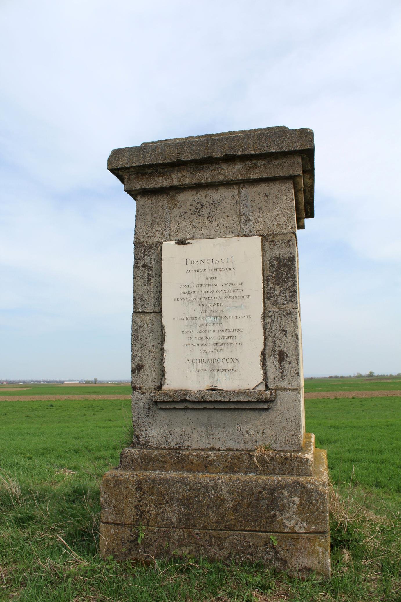
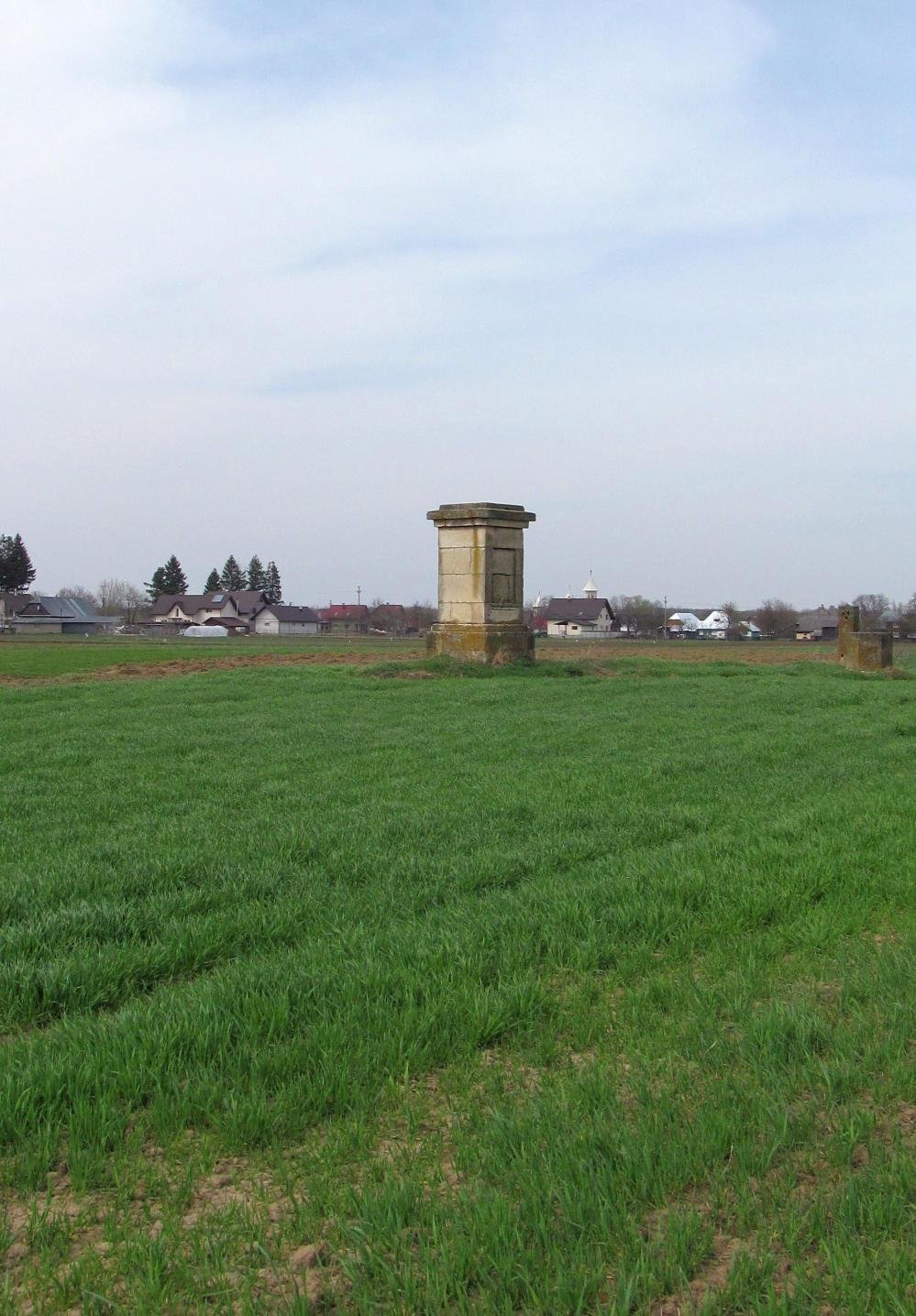
Shortly after the order to implement the Franciscan Cadastre was issued in 1818, land inventory work also began in Bukovina. Since the military triangulation network had not yet been extended to the eastern territories of the monarchy at that time, the province benefited from the construction of its own network of control points (between 1818 and 1820). For this purpose, the leader of one of the triangulation teams from the northern coast of the Adriatic Sea (the Trieste and Fiume districts)—First Lieutenant Alois Hawliczek—was deployed here. He was tasked with coordinating the measurement of a geodetic baseline in the Rădăuți Depression—a landform unit generous in size, devoid of significant topographic relief, and positioned relatively centrally within the province. The geodetic baseline measured by Hawliczek between September 24 and December 30, 1818, had its western terminus near the settlement of Gălănești and its eastern terminus south of Andrasfalva (Măneuți)—measuring approximately 9,861 m. The supervision of the activities fell to Colonel Ludwig August von Fallon, in his capacity as referee for astro-trigonometric works within the measurement directorate of the Higher Land Tax Regulatory Commission.

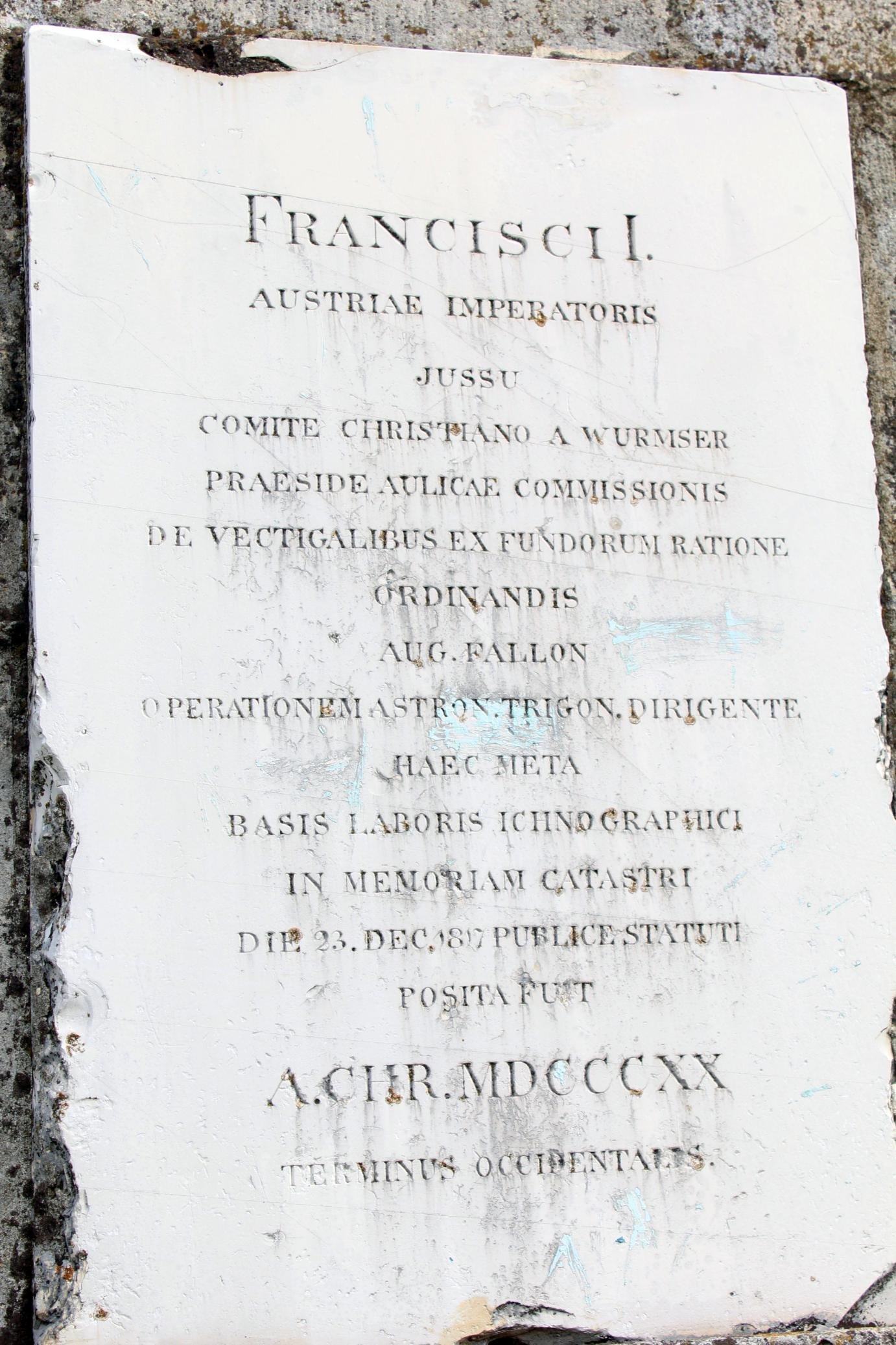
Upon the completion of the geodetic works in Bukovina (1820), the termini of the triangulation baseline were marked by inscribed stone monuments—the earliest known geodetic markers on the current territory of Romania. Unfortunately, only the one at the western terminus (Gălănești) has survived to this day. The existing Latin inscription states:
"BY ORDER OF FRANCIS I, EMPEROR OF AUSTRIA,
UNDER THE DIRECTION OF CHRISTIAN WURMSER,
HEAD OF THE AULIC COMMISSION FOR TAXES ORDAINED
IN ACCORDANCE WITH THE INTERESTS OF THE ESTATES,
THIS MONUMENT WAS ERECTED AS A FOUNDATION IN MEMORY OF THE ICONOGRAPHIC ACTIVITY CARRIED OUT UNDER AUG[UST] FALLON,
DIRECTOR OF ASTRONOMICAL-TRIGONOMETRIC OPERATIONS,
PURSUANT TO THE CADASTRE LAW OF
DECEMBER 23, 1817.
PLACED IN THE YEAR OF CHRIST 1820. WEST BOUNDARY MARKER"5
The points determined by trigonometric methods provided the framework for the cadastral surveys—operations carried out by land surveyors.
The cadastral plans of the province were produced between 1819 and 1823 and subsequently updated/completed between 1854 and 1856. For most of the cadastral sheets, a 1:2,880 scale was used (10 times the military scale). Since Bukovina was one of the few Habsburg provinces where cadastral surveys preceded military reconnaissance, the new maps drafted by the General Staff were created by downscaling (to 1:28,800) the cadastral plans and supplementing them with topographic details. This operation began between 1828 and 1830, when only 28 sections were completed, and would not be finalized until 1863.

A reference milestone in the history of European geodesy was the year 1864, when the "Association for the Measurement of Degrees in Central Europe" was established. Its primary goal was to determine the shape and dimensions of the Earth by measuring arcs of meridians and parallels, a task that required the connection of geodetic triangulations from different countries. From the very beginning, the Association advocated for the standardization of working methods/equipment used, namely, the utilization of the metric system in determining geodetic baselines and constructing standard scales. This system would be gradually introduced in the Austro-Hungarian Empire starting in 1871.
The Franziszeisch-Josephinische Mapping (Third Military Survey)
In this context, in September 1872, Emperor Franz Joseph ordered a new military survey of the monarchy. Compared to previous stages, the new instructions stipulated the use of the metric system, the precise determination of altitudes, the representation of topography via contour lines, and the use of a unified coordinate system. The new military maps were produced at a 1:25,000 scale, while a 1:2,500 scale was used for cadastral maps. The territory of Bukovina was mapped according to the new requirements between 1873 and 1874, utilizing reduced versions of the cadastral sheets—an operation that involved 32 cartographers.
On the occasion of the new military reconnaissance in the province, works necessary for connecting the Austrian and Russian triangulation networks across the territory of Moldavia were also carried out. This activity was of particular importance for Romania, which lacked a modern map of its unified provinces, as well as the technical personnel or funds required to produce one. Consequently, in 1873, when the decision was made to launch geodetic triangulations and conduct topographic surveys, the work began in northern Moldavia, where the construction of the network could momentarily rely "on the precise and technical data of the triangulation executed in the neighboring countries." Responsible for this project were "the three Constantins"—Colonel C. Barozzi (head of the War Depot), Captain C. Căpităneanu (responsible for the astronomic-trigonometric works), and Captain C. Brătianu (responsible for the cartographic component). Throughout 1873, the three officers participated in activities to identify triangulation points in the Iași, Botoșani, Dorohoi, and Suceava districts, and considered the possibilities of connecting the Romanian network with those in Bessarabia and Bukovina.
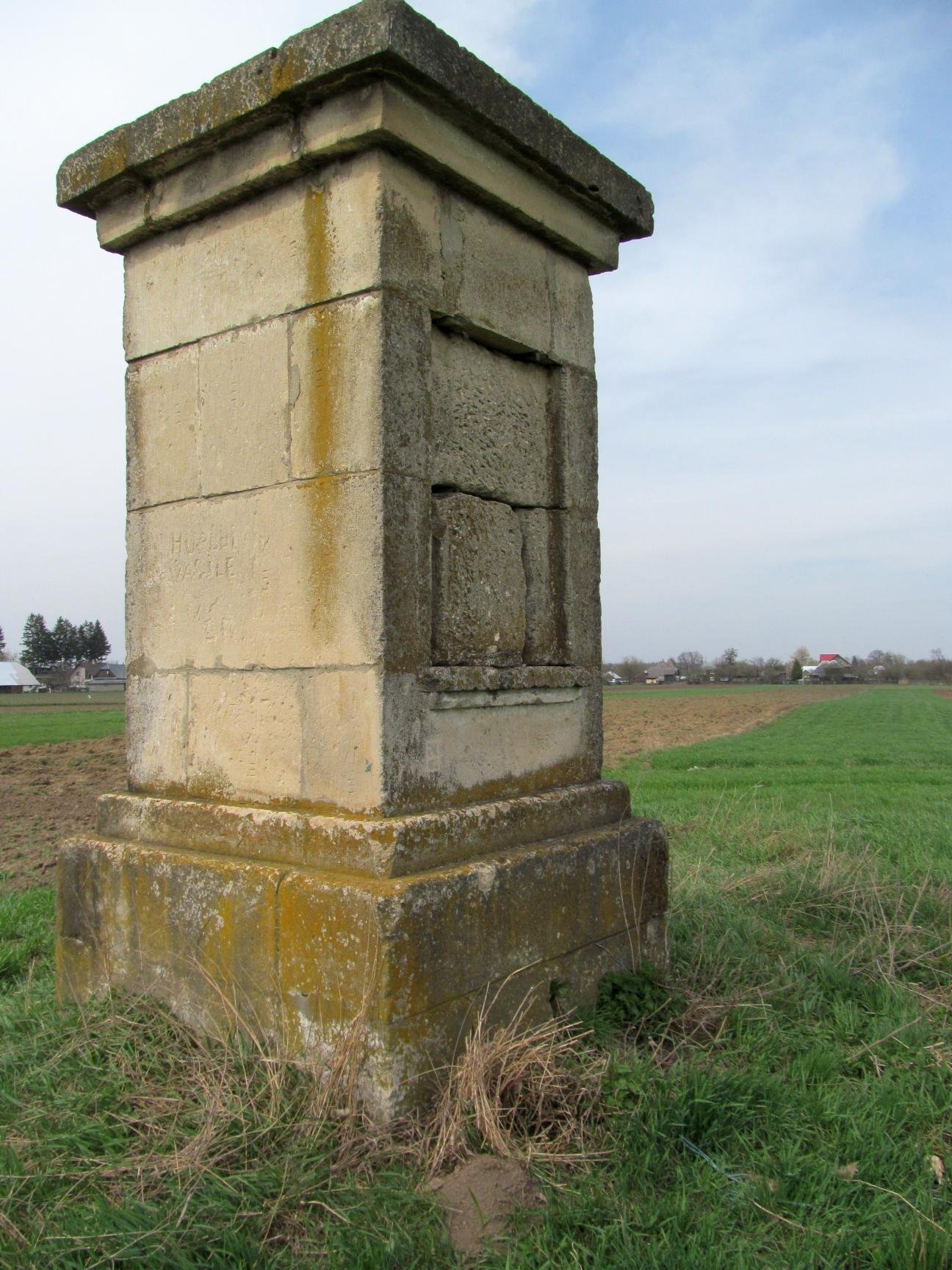
In Bukovina, the Romanian commission, together with the Austrian one—led by the Czech-born Captain Robert Freiherr Daublebsky von Sterneck—determined the connection elements of the geodetic networks between the two countries. Since the Romanian network lacked its own geodetic baseline and the War Depot did not possess the necessary means for its determination, the Austrian baseline at Rădăuți was used for the calculations. It was partially remeasured in October 1874 by Captain Sterneck, an operation witnessed by Căpităneanu as well. Unlike the 1818 measurements, a line of only 2,416 Vienna fathoms (4,566.24 m) was now measured from the western terminus, with the new eastern terminus being positioned south of the settlement of Frătăuții Vechi.
The progressive southward development of the geodetic network in Moldavia served as the preamble to the topographic surveys (1875–1893) and the creation of the map of Moldavia. To commemorate the measurements carried out by the joint Austrian-Romanian team in 1874, another commemorative plaque was placed on the Gălănești monument at that time (on the eastern facade; it is no longer preserved today), while the new eastern terminus of the geodetic baseline was marked with a simple, inscribed boundary marker.
Following this retrospective analysis of the geodetic and cartographic activities in Bukovina, the remarkable progress achieved over the course of a century (1773–1874) by the Austrian administration becomes clearly distinguishable. This progress is embodied in an impressive volume of maps of unprecedented accuracy, produced to the highest standards of the reference period—a true "scientific legacy" regarding the evolution of the geographical landscape, unique within the Romanian extra-Carpathian space. Within this legacy, a special place is held by the Gălănești monument (1820)—the oldest geodetic monument on the territory of Romania, to which the assembly of cadastral sheets is directly linked, and, indirectly, the development of modern geodesy in our country. The network of stable triangulation points established in Bukovina between 1818 and 1820 was the first of its kind on the current territory of Romania, enabling the cadastral mapping of Bukovina in at least two chronological stages (1819–1823; 1854–1856). Bukovina was thus among the first provinces of the Empire to benefit from the implementation of the stable cadastre, preceded only by Lower Austria (1817–1824) and the Littoral Provinces (1818–1822).
- Generalkarte deren Lisieres von der Moldau und der Walachei worin zu entnehmen ist, wie die Sektiones derselben mit jenen der angrenzenden Großfürstentum Siebenbürgen zusammen zu setzen sind, 1769–1773; War Archives, Vienna, AT-OeStA/KA KPS KS B III c 38 ↩︎
- The original version is found today in the Viennese archives—Brouillons der Bukowiner Aufnahme bestehend in 71 Sectionen (aufgenommen durch den k. k. Generalquartiermeisterstab unter der direction des Major Büschel in den Jahren 1773, 1774 und 1775); War Archives, Vienna, AT-OeStA/KA KPS KS B IXa 424; the updated copy, initially intended for the Galicia Command, is located in Bucharest—Brouillons der Bukowiner Aufnahme bestehend in 71 Sectionen, National Archives of Romania, ANB C VII 2 ↩︎
- Plan des Bukowiner Districts bestehend in 72 Sections, welche in den Jahren 1773, 1774 und 1775 von einem departement des kaisl. königl. Generalstabes geometrisch aufgenommen worden. In the War Archives in Vienna, only the inventory card remains (AT-OeStA/KA KPS KS B IXa 425), which specifies "Diese Karte wurde unter der direction des Major Mieg im Jahr 1778 in das einfache Militär-Maß, 1’’=400o, übertragen” and notes the map's absence since the year 1969. Today, it is located in Romania, at the National Archives in Bucharest, under shelf mark C VII 1. ↩︎
- Topographische Bukowiner Kreis-Carte, welche aus denen unter der Direction des deutsch banatischen Gränz-Regiments Hauptmann Hora von Otzellowitz oeconomisch aufgenommenen original Grundrissen reducirt und zusammengesetzt worden, bestehend in 55 Sectionen, worinnen alle Dominien Abtheilungen und Grundgattungen ersichtlich; Arhivele de Război, Viena, AT-OeStA/KA KPS KS B IXa 432. Pe lângă varianta la scara 1:28800, Otzellowitz a realizat şi o hartă mai generală a Bucovinei, cu scopul de a completa harta administrativă a Galiţiei şi Lodomeriei, întocmită de abatele Liesganig în 1774 (cca. 1:72.000); ea este intitulată Bukowiner Kreis-Carte reducirt aus denen unter der direction das deutsch banatischen Gränz-Regiments Hauptmann Hora von Otzellowitz aufgenommenen oeconomischen Grundrissen; Arhivele de Război, Viena, AT-OeStA/KA KPS KS B IXa 433 ↩︎
- Ovidiu Bâtă (2009), Un monument de la 1820 dedicat lucrărilor cadastrale, Analele Bucovinei, XVI, 2 (33), p. 433 ↩︎